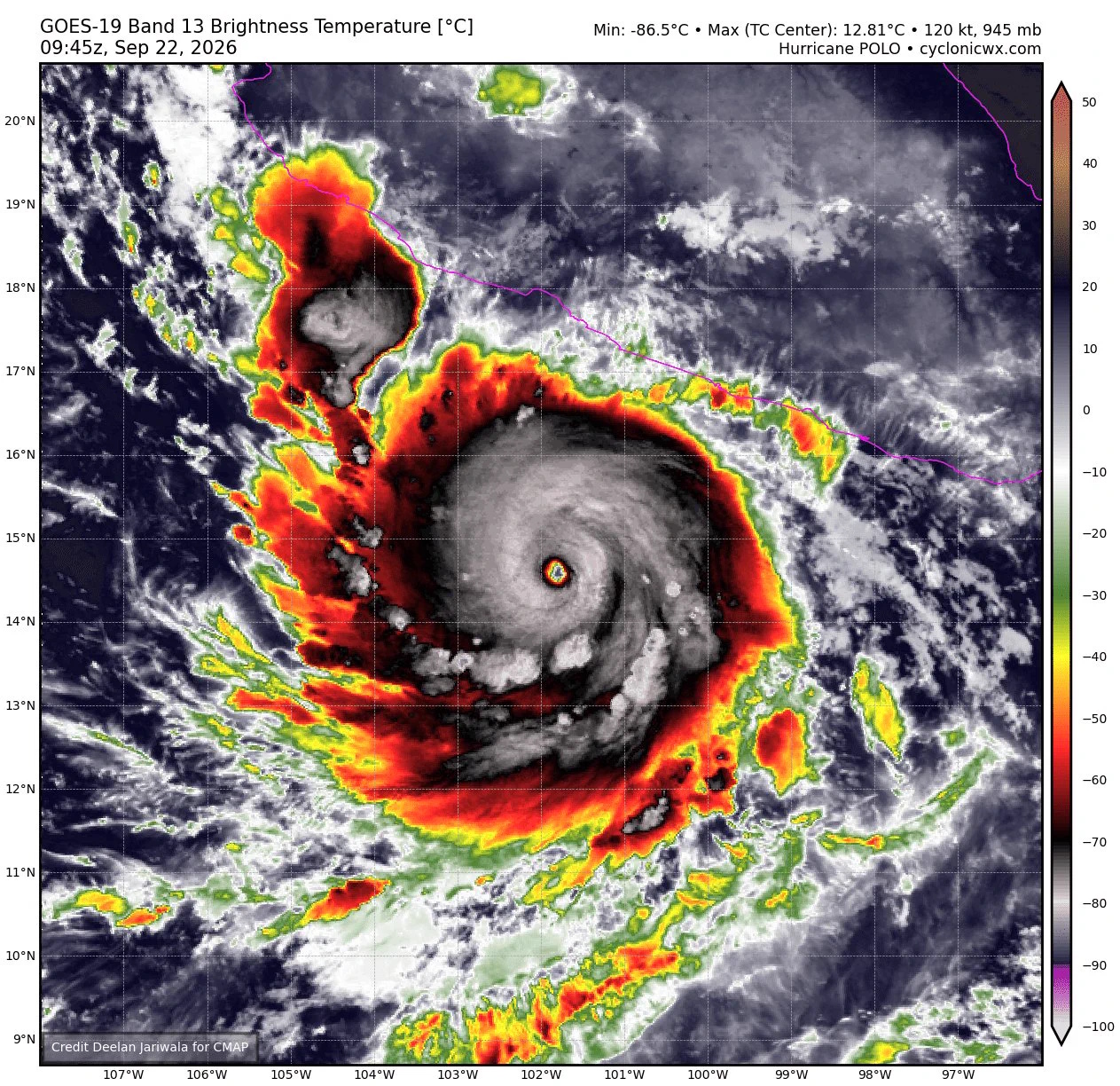
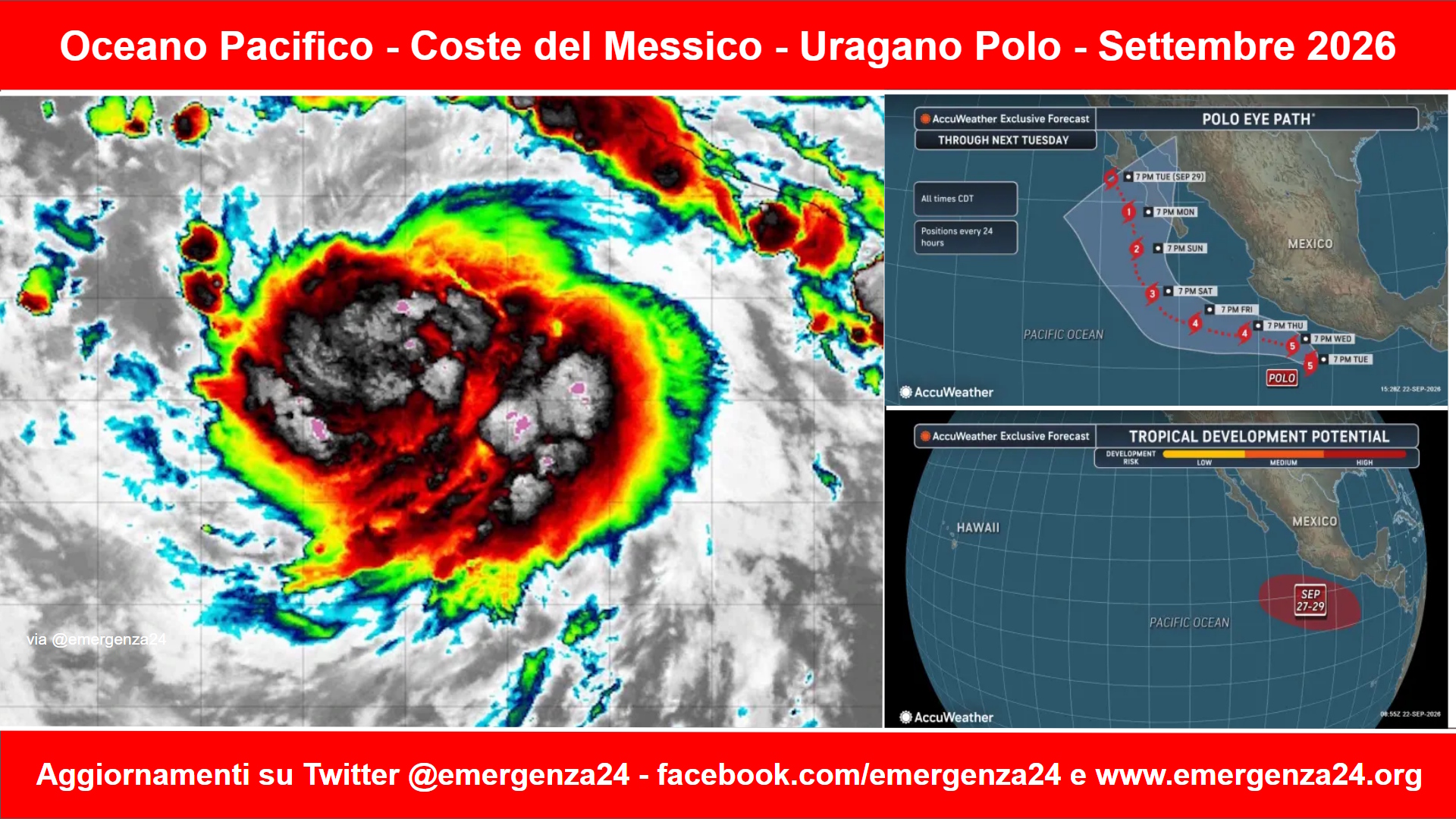
 Preoccupazione per l’avvicinarsi alle coste messicane dell’uragano Polo che si è formato nell’Oceano Pacifico nella metà del mese di settembre 2026 e si sta spostando parallelamente alla costa messicana.
CRONOLOGIA INVERSA
25.09.2026 – 17:00 – Informazioni e aggiornamenti
Category 5 Major Hurricane #Polo rages off the southwestern coast of Mexico in the eastern Pacific 🌀 pic.twitter.com/Zq1YssrR2r
— Zoom Earth (@zoom_earth) September 25, 2026
If there will ever be Category 6, then you’re looking at it now. ✅️
Satellite algorithms blasting upward to T 8.0 –> super intense 🚀
Hurricane Polo had an interesting Thursday with explosive convection in all directions.
Today’s operation: shattering the record book. pic.twitter.com/tfORWeS5DS
— Ryan Maue (@RyanWeather) September 25, 2026
25.09.2026 -16:00 – Informazioni e aggiornamenti
Polo is a Category 5. Again. But that’s not all.
The storm’s winds have now reached 180 mph… and it’s still strengthening. The modern world record is 215 mph (Patricia, 2015).
Next week, Polo is headed to Baja California Sur, then into the Southwest and Central U.S. 😬 pic.twitter.com/C9VgxqkDYL
— Ben Noll (@BenNollWeather) September 25, 2026
24.09.2026 – 23:00 – Informazioni e aggiornamenti
Have to say, #Polo has one of the strangest appearances I’ve seen from a hurricane on infrared satellite. A large and persistent burst of convection in its northwest quadrant is much more intense than the convection in its core. pic.twitter.com/3fDxa462Yl
— Collin Gross (@CollinGrossWx) September 24, 2026
24.09.2026 – 15:00 – Informazioni e aggiornamenti
Hurricane Polo has spent the last 12 hours at Category 5 strength just off Mexico’s west coast.
It’s looking increasingly likely that Polo will cross Baja California early next week, with its remnants potentially producing a serious flood situation in the U.S. Southwest. pic.twitter.com/LWxtLU7f0Z
— Ben Noll (@BenNollWeather) September 24, 2026
24.09.206 – 07:00 – Informazioni e aggiornamenti
Hurricane Polo is looking extraordinary tonight. Sheesh. pic.twitter.com/SgD5dSAyHu
— Dakota Smith (@weatherdak) September 24, 2026
24.09.2026 – 04:00 – Informazioni e aggiornamenti
#BREAKING: Hurricane #Polo has exploded back to a Category 5 with 160 MPH winds. 🌀🌀🌀🌀🌀 pic.twitter.com/uG3p01ZB4V
— Dylan Federico (@DylanFedericoWX) September 24, 2026
22.09.2026 – 22:00 – Informazioni e aggiornamenti
NOAA Hurricane Hunters have found that Category 5 Hurricane Polo, located offshore of Mexico.
Maximum sustained winds are up to 180mph with a pressure down to 892mb pic.twitter.com/PWQM6oLUvb
— World Source News (@Worldsource24) September 22, 2026
22.09.2026 – 18:00 – Informazioni e aggiornamenti
El #HuracánPolo se mantiene en categoría 5 en el Pacífico mexicano.
A las 09:00 h, se localizó a 302 km al suroeste de Acapulco, Gro., con desplazamiento hacia el norte. Se prevé que en las próximas 6 a 12 horas cambie su trayectoria hacia el oeste-noroeste, manteniéndose… pic.twitter.com/0zFfEOybR1
— SEMAR México (@SEMAR_mx) September 22, 2026
El #HuracánPolo alcanzó la categoría 5 frente al Pacífico mexicano después de una rápida intensificación que llevó a autoridades federales de #México a reforzar medidas preventivas. @SEMAR_mx mantiene activo el Plan Marina en nueve estados, mientras que en Colima el Ejército y… pic.twitter.com/TRObYteJhi
— David de la Paz 戴维 (@daviddelapaz) September 22, 2026
22.09.2026 – 17:00 – Informazioni e aggiornamenti
Wow. Hurricane #Polo looks spectacular from satellite this morning 🌀
It’s a category 5 beast with winds of 260 km/h (160 mph), and still intensifying. Luckily, it is still forecast to turn away from landfalling over Mexico. pic.twitter.com/DLlu8rO0rt
— Zoom Earth (@zoom_earth) September 22, 2026
22.09.2026 – 14:00 – l’uragano Polo ha raggiunto la categoria 5, la massima prevista dalla scala Saffir-Simpson, al largo della costa pacifica del Messico. Lo ha reso noto il National Hurricane Center statunitense, secondo cui la tempesta ha raggiunto venti massimi di circa 260 chilometri orari. Il ciclone dovrebbe restare in mare e non è previsto, al momento, un impatto diretto sulla costa. Potrebbe in ogni caso costituire un rischio per il Messico sud-occidentale, dove dovrebbe causare piogge intense capaci di provocare allagamenti e frane, soprattutto negli Stati di Guerrero e Michoacan.
22.09.2026 – 12:00 – Ultima immagine disponibile